
the clouds! like a painting
this sunset beyond the trees
colors float, sun sets
this sunset beyond the trees
colors float, sun sets
First of all let me say that The Farmers Almanac has become , a favorite "yard sale find", next only to insulators.
Though July will always be the 'firefly moon' to me, i must admit i have seen more than the usual number of young bucks, and does with fawns browsing along the greenery where lawn meets the deep woods, not sure why there have been so many this year, perhaps because of the late summer, certainly not because of the nearly non existent berry crop....

July is high summer in full swing. Gardens are heavy with vegetables, fireflies glow after dusk, thunderstorms rumble on humid afternoons, and warm evenings invite us outdoors long after supper. In 2026, July also brings a special patriotic milestone: the United States marks the 250th anniversary of the Declaration of Independence on July 4.
All times below are listed in Eastern Daylight Time.
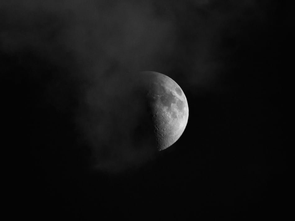
The July Full Moon reaches peak illumination during the morning hours in North America, so the best time to enjoy it will be after sunset on Wednesday, July 29, and again on Thursday, July 30, when the Moon will still appear nearly full.
July’s Full Moon is traditionally known as the Buck Moon because this is the season when antler groth is most dramatic when antlers grow rapidly covered with 'velvet' which contains, nerves and bloodvessels which nourish a the antlers as they grow. While the antlers are still in velvet they are composed of cartilage, which turns to bone.
The full moon of July has many names, including the Buck Moon, with alternative names including Thunder Moon, Hay Moon, and Wort Moon.
So on this this evening, a cloudy one at that, i an watching the skyline waiting to catch a glimpse of the waxing gibbous moon in the southeast.
Good night and peaceful slumbers to all.
Christmas in July, it sometimes make me wonder about many things. One of the most perplexing is how Sasquatch came to be a part of a holiday that some believe started as advertising for an Australian Ski Lodge.
Another story i find totaly charming is that of a Sasquatch who rescued a Postmaster who went out to find the Postal vehicle that was laden with gifts for the people in his town and got lost .
I don't know if the two ever met, but the thoughtful Squatch did make a path for the postmaster to follow home with the gifts and cards.

Summer memories — “When the summer sun finally shows up in the North, what’s the first thing you two like to do together?”
SON-i go with dad down to the creek and catch crayfish.
Holiday meaning — “In your own words, what does Christmas in July mean to your family?”
DAD- that's an easy one, We decorate the house and sing, then the night before we BBQ, and sing songs and wait for Santa to fly over in his plane and drop gifts to us. And leave out some food for the hungry Campers who tromp thru the wood scaring the game, they are usually pretty hungry.
Father–son bond — “How does celebrating in July bring the two of you closer?”
SON- Dad gets time off from his job, he pulls trees out of the ground and then plants them upside down, because the tourists think they are special. I don't like them because the trees don't have any leaves on them anymore.
Traditions — “Do you have any special Christmas‑in‑July traditions that only squatches would
understand?”Yah. and except for this story, Try this link, its sorta like an advertisement.
I-generated image created with Microsoft Copilot, July 2026.

I hope you will try this recipe, click on the word - link - below to watch a remarkable lady in action preparing this pie.
So tasty and really if you have any doubts about your pie crust making skills, like i do. Notice that a pie shell was used, but it is OK to make your own pie crust if you prefer to do so.
Try this recipe and enjoy the video!


wAS IT YESTERDAY?
YOU TAUGHT ME THE FLOWER' S NAMES
I DRIFT OFF REPEATING
Not all that far from where is used to live there is/was an abandoned stone quarry. A place just waiting for adventurous children of all ages, and in an even earlier time moonshiners. It gradually became a site of paranormal {not the term we used then} events, and abductions of unwary young people, ghostly sights and sounds, all the sort of tales made up in my not so humble opinion, buy parents. Oh, and there were also mountain lions sighted there, which at least turned turned out to be true.
Anyway, where was i going with this, ah yessssss!
I find these places interesting, and the Humber Stone, is no exception. Since roughly 90% of the earths crust contains silica, and silica which is used to make chips, computer chips , is the earth then some sort of computer???? Saving bits of information , words , thoughts, symbols etc, etc and resembling them?
I think, yah, i know!, i think too much. But i digress and i do that too much also. I think there could be a syllogism written to prove that " one never knows what one never knows."


Daily Grill–style
Butter
1 onion, chopped
2–3 cloves garlic, minced
Tomato purée
Paprika
Red lentils
Bulgur wheat
Chicken stock or broth
Chili flakes (for serving)
Dried or fresh mint (for serving)
Fresh lemon juice (for serving)
Sauté onion and garlic in butter until soft.
Add tomato purée and paprika; cook briefly.
Add red lentils, bulgur, and chicken stock/broth.
Simmer about 30 minutes, until lentils are completely soft.
Purée the soup until creamy and smooth.
Finish with chili flakes, mint, and a squeeze of lemon.
Longer cooking of the tomato purée adds sweetness.
Broth works just as well as stock.
Fresh mint is lovely if you have it.
The soup develops deep flavor in only 30 minutes.

the clouds! like a painting this sunset beyond the trees colors float, sun sets

